Category Archives: peru

167451****

walmart, it turns out, exists in argentina too. i was hoping to score some really low-cost tires, but the cheapest was only about 5% cheaper than in puerto madryn (or about twice the price in the us). the car is certainly starting to make more noise than before, and the steering feels a bit strange (kinda like a loose belt or flat tire). i think another cv joint might be on it’s way out, but no noise yet. or maybe it’s because the camber angle of the front wheels are now different.

mar del plata is a nice big city — i think i like cities. we got in kind of late, so didn’t get to see much….but from what i saw, it seems quite nice — according to lonely planet, it’s kind of the getaway for the rich from buenos aires (but it also has a population of about 800k). we’re in the same room as a couple of kite boarders from buenos aires….apparently kiteboardng is pretty big around here.

also, courtesy of francois, here are some pics from our time in northern peru (where the sentra got a broken cv joint, a short in the brake switch, was stuck in a ditch….and both the sentra and i were throwing up liquids because of the altitude….good times!): http://www.facebook.com/album.php?aid=2215585&id=225041&l=8ab9f63ddc

(a few of Francois’ pics are below)


157721

the border between peru and chile at tacna is really nice. the peruvian building was finished in 2007…and everything was clean, simple and modern (it took under 20min). on the chilean side (which took about 30min), they scanned both my bags AND my car. to scan the car, they had this large truck, with an arm sticking out of it…and then they just drove the arm over the car. nonetheless, they didn’t catch my secret side-wall compartments filled with books, granola bars and water.

157698

today. i drove to the border town of tacna. tacna is another typical peruvian town, with typical peruvian people….i’m ready for some change. they do have a cool train museum, though….it’s more like an old train station (with tons of repair equipment) that’s been abandoned for over half a century. you can just walk around and climb/touch everything. tacna is also overrun with pigeons.

the drive today took me through quite a bit of desert — it’s impressive how much desert there is in the americas. tacna is right in the midde of it….pretty impressive to see such a large city (couple hundred thousand) in the middle of nothing. i also followed a van for a bit which said ”panamerica-movie.com’, i think (i still need to check it out).

peruvians don’t seem to have respect for road rules. why do i say that? well, it seems like half of the road signs on the highway are non-informative. for instance, they’ll say ‘respect the signs’, ‘don’t break the signs’, ‘trust the signs’, ‘don’t pass if you’re in doubt’, or ‘don’t speed, think of your family’. then, there’s traffic cops….who people also don’t respect. it’s not that they don’t like them (that’s more or less universal, afterall), but that sometimes cars will just ignore them….like the taxi in huaraz which just drove by one flagging him down. or when the cops pull me over, they’ll look everything over, make me wait a few minutes, then ask me for a ‘coke’ or a ‘lunch’ (aka cash). in other countries, they’ll make up some infraction and threaten you for a bribe. here, they just implore you for a handout…..like those litte kids on the cordillera blanca who would always say ‘regala me!’….and you’d appease them with a piece of hard candy.

157456

note: time of gps is wrong

well, the food poisoning finally hit me. last nigt i got up at least a dozen times, and this morning’s guided tour of a museum was hell (every few minutes i’d get cramps….i don’t think i could handle giving birth). but, now everything’s ok again…i think…which is good since i have a 6hr drive to tacna tomorrow.

like antigua (guatemala), arequipa has some towering mountains surrounding the city — they’re an awesome surprise and add a whole other dimension to the city. recently, the glaciers on the mountain tops have been melting (not necessarily because of global warming), which may sound like a bad thing…but on the plus side they’ve exposed several inkan burials. one frozen burial of a 12 year old girl, ‘juanita’, was preserved very well (skin and internal organs still intact) and can be seen at a museum here. scientists have even determined how the girl died (blow to the head), when she last ate (8hrs before death) and what her last meal was (vegetarian).

157455

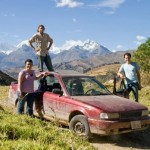
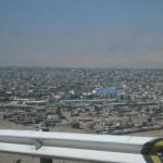
today’s drive from puno to arequipa started off a bit rough…with me having to crank the engine for about a minute before it started. arequipa’s a little lower and a little warmer, so hopefully it will get easier. however, the mountain pass between the two cities reached an elevation of almost 3 miles, it’s incredible that the car can still run smoothly at such a high altitude (fyi — mount everest is about 5 miles).

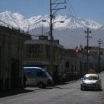
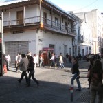
arequipa center is a nice little colonial city, with a few interesting touches. for instance, rather than beeping (for the blind), the crosswalk plays a little song when it’s ok to cross. however, the song is always the same…which is probably a good thing for the blind people, but could be annoying for nearby employees. i also saw an owner hand-washing the individual leaves of the plant outside his restaurant. later, i visited the monasterio de santa catalina. lonely planet states it’s a ‘paradise for photographers’, so rather than post my shitty pictures, you’ll be better off searching the web (…i also forgot my camera in the car). the monastery is still functioning and is very big (it has little streets) and serene inside…it’s like another world.

ON GPS
when people here learn about my trip, they’ll typically be surprised by two things: one, that i’m driving alone; and two, that i don’t have a gps (which is often called ‘gps’, even in spanish…rather than ‘spg’ like the acronym should be). my answer to the first is that i’ve met friends along the way, either who live in latin america or who flew down for a leg…but that while most people are excited by the trip, they can’t commit because of real or imaginary obligations (real: family or mortgage, fake: scared to leave their job). the navigation question, however, is more interesting.

it was my original intention to buy good maps every time i entered a country. i assumed that i could get a good aaa-equivalent map at the gas stations, etc. probably not surprising to you, getting good maps is much harder than in the us. luckily, since i don’t have a real destination…having a map is not as important (…i mostly head south). lonely planet usually provides a good enough map that will get me around, although i’m sure i’m missing good places (for instance, my lonely planet isn’t big on camping…so i’ve mostly stayed in hostels and hotels). in addition, i borrowed santi’s gps unit in san jose, costa rica & i bought some detailed maps in panama city. having the gps made it much easier to navigate the busy city, as i was able to visit multiple shipping agents in just a few hours.

even the best maps of latin america, though, are just guides. in the united states, the streets and buildings are almost always clearly marked. with a map and some patience, you can usually get anywhere you need to. many latin american cities (and all towns) lack street signs and numbers. in panama city, for instance, street names on the map were different than those on the streets…and locals often times knew neither. in san jose (costa rica), houses don’t even have addresses (well, not in the traditional sense…instead they’ll write down that they live ’50m north of the coca-cola distribution plant’).

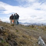
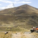
so how can you get around a place without a codified grid? sometimes i’ll follow cars….hoping they’ll lead me to the tourist destination (sometimes this backfires and i end up in a tiny suburb/village). highways will sometimes have mileage markers….with the zero typically being at a big city (although sometimes the distances will go up, then back down again). other times (esp in central america), you can spot the center of town by the big cathedral (thank god for the catholic missionaries!). but usually, i’ll ask people (in fact, i typically will ask a few people and follow the most common response). it’s also incredibly important to understand your audience….a taxi driver will usually know the area better than a supermarket clerk (who today gave me the exact opposite, and wrong, response as the cab drive outside).

but, back to gps, it seems like it can have a huge impact in 2nd and 3rd world nations. well, probably not with the current user-interface…and maybe even with different technologies (bottom-up vs. top-down). but, some sort of virtual navigation system has the ability to leap-frog the burdensome signage system present in the us…in much the same way that cell phones have leap-frogged landlines. one of the most important elements, though, is access — both access to update the information and access to the information itself. whereas signs can be costly to install/maintain….their access is free and ubiquitous. virtual navigation systems will likely need a similarly low-cost, universal approach.

but for now, i’ll just keep taking the ‘scenic route’….on purpose, i swear.

157253

this morning i drove to puno, the small port town on lake titicaca. i quickly hopped on a boat which took me to visit a few of their floating islands (built by the uros tribe). the islands are actually very neat: comfortable, pretty, simple and a cool engineering feat. what’s really impressive is how sturdy they feel…i was expecting them to rock around like a dock, but they’re actually very stable; and comfortable too….one kid was doing flips and landing on the soft reed floor.

the islands are probably about 30m x 30m (or less) and made from a stack of 2-3 meters of reeds (plus dirt); they are then tied down to the lake bottom so they don’t float away and accidentally start a war with bolivia. some islands have holes in the middle to farm fish, while others have hostels and schools. the majority of the construction is from reeds, although wood and metal are finding there ways onto the islands (along with a couch in the hostel). one interesting thing about the reed roofs, is that they apparently swell up when it rains…thus creating a water-tight seal (or so they claim). reeds are also grown on the islands (the island is living), so that it is more or less self-sustaining (every year they place down a new layer of reeds). they also make boats from the reeds….one boat takes a couple weeks to make and lasts from 1.5 – 3 years (depending on if a plastic tarp is used in the construction of the reed floats). i was also surprised that there weren’t many bugs on the islands; after all, they seem like a pretty good place for decaying vegetable matter and insects (reeds + water + sunlight).

overall, the idea is really elegant and seems environmentally sustainable — probably one of the most exciting systems i’ve seen yet (even more elegant than the panama canal).

but now for some downers. first, although people ‘live’ on the islands, they survive entirely off of tourism. the islands themselves are built and maintained for tourists (some of the islands were built as recently as 2000). also, on my boat, i think there were some uros pretending to be tourists…and buying little trinkets at all the islands, then showing them off in hopes that we would buy stuff too. also, as patrik warned me, the boat tour lasts a bit too long….they kinda trap you on the islands so you’ll buy stuff. finally, i don’t like to publish criticisms….but contrary to what everybody’s said about peru, i’m ready to leave (…well at least the highlands region).

as a side note, this evening my car is residing in the high school stadium parking lot….which also happens to be next to ‘singer’ alley (seriously, 8 identical little carts with beautiful singer sewing machines).

157224

well, i’m now in juliaca…just outside of lake titicaca. today i saw some more cool inka stonework at moray, then drove into cuzco. in cusco, my exhaust pipe broke again (since lima, it had been broken just before the muffler….which was loud….but not as loud and polluting as the second break before the catalytic converter). so, i stopped by a repair shop and paid $7 for him to weld the whole thing back up. afterwards, i started my drive towards lake titicaca. the first town i stopped by had a nice church, but it was too early in the day for me to spend the night there. the next city was a good time to stop…but the city/hotels were pretty bad. so, i decided to head all the way down to lake titicaca….well, to juliaca…which has nice hotels.

because it was kinda far, i had to drive at night. peruvians have no high-beam etiquette. none. in my experience here, the best way to get on-coming cars to switch to low-beams is to keep your high-beams on….kinda like a game of chicken. most will finally give up and switch. of course, some will stick it to you by turning on their high beams again at the last second. cars behind you are no better, often keeping their high beams on, even when they’re just 20 feet back. i also, may or may not have outrun a police car. i’m not too scared of the cops anymore, so i’ll sometimes pass them (in this case, another car passed the cop first). afterwards, the cop put on his highbeams, then switched his lights so only his right beam was on (which i think is a sign for me to pull over). i figured that if he really meant it, he would put on his siren or pass me. but, i lost him in the dark. the third experience on my night trip was the road detour just outisde of juliaca. the nice paved road detoured into dirt…well, actually, into a desert-like terrain. a few minutes into the detour, i nearly drove into a ditch. at that point, i looked around, and noticed another bus a couple hundred yards away…to the side of me. luckily i was able to get back on course and follow the bus to safety.

tomorrow, i head to lake titicaca, then to chile, then to iguazu falls.

156927

this morning the friendly receptionist at machu picchu inn let me use their wifi for free (…a good thing, since rooms start at $200). at that time, i was able to read erik’s recommendation to climb up putukusi (the mountain directly across from machu picchu).

the hike up had some cool sections (climbing up ladders on steep rock faces in a jungle-like environment) but can best be described as steep, tiring and boring (for most of the hike, you can just see the trees and vines). i lost my respect for erik during the 1 – 1.5hr hike….but after sitting up top for a little while, he regained my respect. the view is very nice….and has a cool perspective on machu picchu. it was so nice that i sat up there for about an hour. i also met chuck, an engineer from texas who warned me about the dangers of socilaism in america (he also asked me to take a picture of him under the huge gay flag of the inkas…not sure if he realized the double-meaning of the flag). later on, i met carlos, a school teacher from lima who shocked me by suggesting that my spanish accent sounded brazilian…without knowing that i was brazilian (i had earlier told him i was american…but apparently i now sound more brazilian than american!)

Question Of The Day: Are peruvians surprised to find that san francisco’s (homosexual) castro district is not full of inca’s?

PICS:
1) aguas calientes from mount putukusi
2) a ladder on the hike up mount putukusi
3) i wonder where they stole this logo from?
4) the bus mechanic / underwear drying facility (i never thought about it before, but maybe theyre related businesses)

156926

today i went to machu picchu. it’s an incredible place for a number of reasons:
1) growing up, machu picchu has always been described with awe and reverence. i feel that if i were to say or think anything negative, it would be blasphemous.
2) the site is placed on the top of a mountain ridge and is surrounded by other steep mountains (with a small river surrounding machu picchu). because the mountains are so steep, they’re also quite close, and it’s almost surreal to be enveloped by these massive walls of green.
3) although machu picchu may have looked much different in the past (gold, plaster walls, etc.), it is a really incredible piece of art now. it is grand like an ancient castle or fortress, but it’s also very organic and seems to rise from the mountain top. indeed, quite a few of the walls are actualy built around existing boulders (which were often carved in place to become part of the wall). only a few places have the incredible inca stonework that i expected the whole site to have….although even the sub-prime stonework is still impressive, especially from a distance.
4) machu picchu is quite small (as i learned this morning, you can sprint/jog from one side to the other in a few minutes), however, it’s full of awesome nooks and terraces from which you can sit and admire the stonework and surrounding mountains. indeed, even with hundreds of tourists, you can easily find a quiet little corner to relax in.

so why did i run? well, they only allow 400 people to climb huayna picchu every day (the famous mountain in the background of almost every picture of machu picchu). so, i woke up at 4am, then waited in the bus line in aguas calientes (machu picchu pueblo) for the first buses which leave @ 5:30am. at the top, we waited in line again to enter the park…then sprinted to the other side where you wait in yet another line to sign up to climb the mountain. i ended up being number 87, and got to start climbing the mountain at 7:30am…..then no more lines for the rest of the day!

a few asides:
– getting a tour guide is not necessary, since there are already so many guided groups there. if you wait next to any place for a few minutes, a spanish or english group will show up…and you can eavesdrop easily. also, that way you can see the site in any order you want.
– americans tourists are almost always paranoid about their citizenship, and pretend to be canadian or wear local clothes (i’m no exception, and have chosen to travel most of this trip with my brazilian passport). locals can obviously see through this, but the ironic thing is that most people from other countries try to look american (american brands or shirts with stuff like ‘texas longhorns’).
– my shower in aguas calientes is actually quite cold.

PICS:
– were the sizes of arrows and text on ths sign intentional?
– it’s beautiful how the randomly sized rocks are fitted together to form a uniform object. it’s even more incredible when the boulders are parts of the mountain and are then carved in place. i love it when one rock can be part of two or three walls…or even part of the floor. it’s such a different mentality than what i’m used to: uniform bricks and materials which are repeated to form simple shapes (we live in a world of legos).
– temple of the sun with huayna picchu in the background
– macchu picchu terraced hillside with huayna picchu in the background
– surrounding mountains

156925

peru offers three different style trains to machu pichu: the simple ($30 – 40), the medium ($40 – 60) and the extravagant ($300). because the fare was only $40, i decided to take the medium (vistadome) to machu picchu and will take the cheap (backpacker) out of here. the vistadome is not as extravagant as it sounds….from the inside, the train looks a little bit like what people in the 1920s thought trains would look like in the future. periodically, pre-recorded messages (in spanish and english) would tell us safety messages, etc. the spanish version was a very proper woman who annunciated everything perfectly. surprisingly, the english version was not from a peruvian butchering english….but instead from an american with no voice training at all…perhaps a tourist who made a few exra bucks. the train steward made his own little inca wall, piling up 20+ bags in the doorway to create a sturdy tower almost 6 feet high.